We continue with our approach to the Rocky Mountains of Canada. And for this we tour the interior of the province of British Columbia in a 3-day roadtrip between Whistler and Jasper. A total of 1,300 km of changing landscapes, valleys and rivers, snowy mountains and yellow fields. Although without doubt the star of this area is the Wells Gray Provincial Park, which has some of the most spectacular waterfalls in all of Canada. We tell you how to visit this park and the rest of the points of interest and stops along the route.
Stage Information
Stage 1: Whistler - Kamloops (319km)
Stage 2: Kamloops - Valemount (443km)
Stage 3: Valemount - Jasper (268km)
Total km: 1,030 km
Stages of the roadtrip through the Rocky Mountains:
- Day 1: from Vancouver to Whistler (Sea to Sky Hwy)
- Days 2, 3 and 4: from Whistler to Jasper (Wells Gray Provincial Park and Mount Robson)
- Days 5, 6 and 7: Jasper National Park
- Day 8: Icefield Parkway
- Days 9 and 10: Banff National Park
- Day 11: Yoho National Park
- Days 12 and 13: from Revelstoke to Vancouver (Kootenay and Okanagan regions)
This is the travel map of 3 days between Whistler and Jasper, with all recommended stops:
We would still have a piece of Sea to Sky Highway that we did on this day. We also enter into the interior of British Columbia, passing through quite interesting landscapes and places.
We started the morning going through the Tim Hortons of Whistler and headed towards this park, next to the lake Alta Lake. And we had one of those memorable moments that roadtrips offer you, of peace and harmony with the world, with a "good" hot coffee in your hands, the clarity of the water and the snowy peaks on it. Of those that a simple photo could never describe.

More than some waterfalls, they are rapids through huge rocks, that being there, one wonders how they can continue to endure the erosion of the force of the water. The road is from 1.5 km almost unevenly and always following the course of the river.

The road begins to climb, the peaks around us are getting whiter, and the temperature drops a few degrees. We are going through one of the many mountain ranges in the area, and this one in particular has the Joffre Lakes as a central element They are 3 alpine lakes (Lower, Middle and Upper Joffre Lakes) that can be discovered through a trail.
The walk to the first one is short (10 minutes from the parking lot) and flat, although at the time we went (early May) the road was covered with snow, and it gets a little complicated. That was the perfect excuse to just visit the first one and settle for the views of this beautiful lake and the Matier Glacier in the background. If you want to reach the second and third, the path begins to gain elevation and the total route is 10km i / v.

At the roadside ladder we found this viewpoint over the Seton Lake, one of the hundreds of lakes that you will pass on your route. If you look, at its right end you will see a line of railroads winding with the silhouette of the lake. Here should pass the Kaoham Shuttle, a small panoramic train that travels daily between the nearby Lillooet, Seton Portage and D'Arcy at the other end of the lake. The price to enjoy this interesting plan is also very affordable: 10CAD for the round trip (between Lillooet and Seton Portage, if you want to get to D'Arcy the price goes up considerably), yes, you will have to book with enough time in advance (tlf: +1 250-259-8300).

From there to our final point in Kamloops, the landscape is changing. From the high mountains, green and white, we go to a much drier panorama, with much more heat, although with mountains and lakes everywhere. We go through the first Marble Canyon, with a marble rock on the left. Then before engaging with Hwy 1 (the Trans-Canada road) is the Historic Hat Creek, a kind of town in the purest farwest style (admission is paid). And then we stop to eat an improvised sandwich in Juniper Beach, where there is a campsite and, well, little beach ... but it is quite nice.

Is the largest city in this part of the roadtrip (90,000 inhabitants) and where you will find more accommodation options. You will also have all kinds of businesses, including Walmart, where we go before leaving the city to stock up on a few offers. Kamloops is located on the banks of the Thomson River and when you get close you will realize that it has a much more arid climate than the rest of the area. The colors have changed from green and blue to yellow and brown. But in general you see a pleasant city (with a few crazy people walking through its streets).
You can't miss a dinner at the Noble pig, and the next day have breakfast on a picnic plan in the park Pioneer Parkat the foot of Red bridge, a historic bridge built in 1887 (in the largest Riverside park parking is paid). Do not forget to keep an eye on the calendar of sporting events, as Kamloops is known as the Canada tournament capital,
Curiosity: in the 1890s, approximately 33% of the inhabitants of Kamloops were of Chinese origin. This is due to the need for labor for the construction of the Canadian Pacific Railway, which crosses Canada from east to west.

It is time to take Highway 5, which we will take throughout the stage today. With this road we will approach the rocky mountains and we will have a small advance, especially at the end of the day. But first we will make an intermediate stop to visit the Wells Gray Provincial Park.
It is the fourth largest park in British Columbia and crosses the Clearwater River Valley, leaving a few shocking images at your sides. To visit it, we advise you to go first Clearwater Visitor Center, and from there line the Clearwater Valley Road, the road that runs parallel to the river and from where we will have access to the most interesting points. The park has camping options and if you just want to visit it during the day it is free.
This tour is divided into Two parts: the first 47 km are on a paved road in very good condition, leading to the Helmcken Fall, the star attraction of the park. From there there are approximately 21 km along dirt tracks to the Clearwater Lake campsite, which we find closed for being out of season and which we also believe is not worth it.
We take 47 km one way and 47 km back some Three hours, and that we did not do any long trekking! But there are several points that you have to visit if or if, and these are:
- Spahats Creek Falls and Shadden Lookout:It is the first of the various waterfalls that you will find in the park, and for us the most impressive. Not so much for its height (60 meters), but for its enclave. And, this may have been one of the most impressive waterfalls we have ever seen. The viewpoints, just 5 minutes from the parking lot, are located on the edge of an immense canyon where the water fall precipitates, and it is impossible for one to not shake a little the legs when they peek over the cliff.
After this visit, we recommend you follow the dirt road until you reach the Shaddden lookout, a viewpoint from where you will have wonderful views of the valley and of what is, after all, this park. Curiosity: the word “spahats” is the one used by the First Nations that populated these lands to refer to the bear.

- Moul Falls: they are the next waterfalls on the road, which we do not visit, because for this we must do a 2-hour trekking (round trip). You will find an observation platform at the top and you can also go down to enter the back of the waterfall, the only chance to do it in the park is here.
- Green Mountain Viewing Tower: on this detour there are several paths through the forest, which may interest those who go in search of sweating the fat drop. But also a tower on top of a hill, above the park and all the snowy mountains that surround it. The road is 4 km and is made of dirt and stones, although any car can do it.

- Dawson falls: It is the least impressive of the waterfalls. There are more rapids in the river. To get there, you have to make a path about 15 minutes from the parking lot. Just before arriving there is an exit to the right where one of the many trekkings through the Clearwater River valley begins, although the interesting thing is that the photo is very cool from this panoramic point.

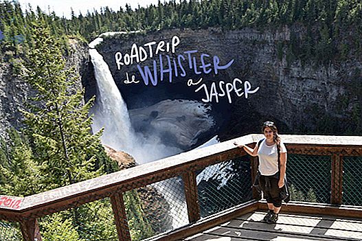
- Helmcken falls: It is undoubtedly the main attraction of the Wells Gray Provincial Park. This waterfall of 144 meters is the fourth highest in BC, and can be seen from several viewpoints just 5 minutes from the parking lot. Looking down to the base of the waterfall, you can see how the erosion of the water and its volcanic origin have caused a kind of cave to form, where most of the time snow and ice is concentrated, as if it were an off-site glacier . If you want to go further, there is the Rim trail than 1 hour that will offer you other points of view of this spectacular work of art of nature.

We finished this third day tour from Vancouver in this beautiful town, almost completely surrounded by mountains that still conserved snow in its highest parts. It is the closest town to Jasper National Park, and where the Rocky Mountain adventure will officially begin. It is a relatively new town, formed by an intersection with a few roadside motels, gas stations and fast food restaurants. And a tiny urban core, where you can't miss a visit to the 3 Brewing Ranges And try some of their craft beers (some say they are the best in BC!). Good place to stop along the way and take energy for the next trips. And if you do it in an accommodation like ours, the Teepee Meadows, you will feel like a real Canadian cowboy!

Before leaving British Columbia and moving to the province of Alberta and starting the tour of the Rocky Mountains, we had a stop for those that encourage the trip: Mount Robson, a good mountain trunk to welcome us to the cold Canada!
About 30 km from Valemount we can admire this huge mountain, which with its 3,954 meters, is the highest in the Rocky Mountains Canadians You can photograph it perfectly from the viewpoint of the Mount Robson Visitor Center, although there are also long path options that approach this colossus. The most famous is the Berg Lake Trail, 19 km, which surrounds the mountain on the right and reaches the Berg Lake, from where you can see the north face of Mount Robson, much more glacier than the south, and the Berg Glacier. You can shorten this trek by arriving only to Kinney Lake (10 km and 2.5 hours round trip).

From Vancouver to Jasper there have been 4 intense days of road, with lots of spectacular stops and scenic places from which one can never tire. But the good starts now! We are already in the Rocky Mountains of Canada, and the thing looks good!
This was the summary of roadtrip between Whistler and Jasper, in total 3 exciting days, with special mention to Wells Gray Provincial Park and its powerful waterfalls. We hope it helps you to plan your trip through this area of Canada!

Save on your trip
Flights cheap to Canada: bit.ly/2PzteoK
accommodation Cheap in Canada: bit.ly/2ZK4TBl
Stay withAirbnb and get€ 25 discount: here
Activities and excursions in Canada: bit.ly/2VAT94W
Rent a car with the best discounts: bit.ly/2xGxOrc
Travel insurance IATI with a5% discount: bit.ly/29OSvKt
Books and travel guides: amzn.to/2GSrvIA
All our articles about canada